Showing posts with label Imaging Satellite. Show all posts

Tuesday, September 09, 2014

Chinese Remote Sensing Satellite Yaogan-21 Launched Into Orbit

China has launched two satellites into orbit -- Yaogan-21 remote sensing satellite and the Tiantuo-2 satellite -- from the Taiyuan Satellite Launch Center, in north China’s Shanxi Province.

The Yaogan-21 will be used for scientific experiments, surveying natural resources and crop yields and helping with disaster relief. The Tiantuo-2 is designed for small satellite experiments.

Thursday, April 17, 2014

Surrey Satellite U.S. To Introduce Color Video-Imaging Small Satellite

Surrey Satellite Technology US LLC (SST-US) today introduced the Surrey V1C color video-imaging satellite, a new compact design with high-quality imaging at sub-one-meter resolution. Priced at less than $20 million, the V1C design has significant space heritage and provides a 10-kilometer color video imaging swath.

The Surrey V1C satellite will collect high-definition, natural-color (red, green, blue) video with better than one-meter ground sample distance (GSD) resolution over a 10-kilometer-wide swath at up to 100 frames per second. In addition to video, the camera can operate in still scene imager mode. The Surrey V1C spacecraft is based on the new SSTL-X50 satellite bus derived from mission-proven Surrey spacecraft designs. The satellite has large onboard data storage capabilities for store and forward as well as real-time downlink technology.

SST-US announced plans for the Surrey V1C satellite in booth #2090 at the GEOINT 2013* Symposium being held this week in Tampa, Fla.

“The demand for high-quality, wide-swath video solutions from customers engaged in business analytics and U.S. geospatial intelligence missions has been a key driver behind the development of our current suite of affordable, high-value small imaging satellites. The V1C delivers next-generation video capability at a very low cost, helping close the video-derived products business case and serve intel mission profiles that require constellations for a robust end-user information products,” said Doug Gerull, SST-US’s chief operating officer.

SST-US has been developing a new complete suite of high-value, affordable small satellites for U.S. geospatial intelligence missions, Gerull explained. This suite includes the Surrey V1C and the Surrey L1 half-meter electro-optical imaging satellites announced at GEOINT. These mission-configurable spacecraft are applicable to a broad spectrum of intelligence collection requirements, such as surveillance, detection, and identification.

SST-US developed the Surrey V1C for organizations that need satellite data to be collected and analyzed quickly for situational awareness and activity-based intelligence (ABI) applications related to rapidly changing human or infrastructure conditions on the ground.
“The primary use of video imaging from space is to quickly understand activity on the ground and make informed decisions in short periods of time. The basic limitation of time-over-target for video can be overcome by a constellation of satellites made economically feasible by a low cost per spacecraft,” said Gerull.

Demonstrated architectures and cost-effective prices mean Surrey’s geospatial intelligence satellites are well suited to multi-satellite constellation configurations. Many on-orbit configurations are possible depending on the number of satellites launched—Surrey V1Cs can deploy in phased orbits trailing one another by 30 to 60 minutes, in order to provide nearly continuous video coverage during specific times of the day.

SST-US’s new manufacturing facilities in Englewood, Colorado, allow the build of V1C satellites in the U.S. and accelerate Surrey’s already proven fast build times. The Englewood facility is currently processing the Surrey Orbital Test Bed mission which will host high-value payloads from customers such as NASA JPL.

Leveraging Surrey’s 100 percent successful 41 satellite mission legacy, SST-US is also positioned to assist satellite customers with launch services and satellite command and control.
          
About Surrey Satellite Technology US LLC
Surrey Satellite Technology US LLC (SST-US), a wholly owned subsidiary of Surrey Satellite Technology Limited (SSTL), is a Delaware-registered company with its principal offices located in Englewood, Colorado. Since its incorporation in 2008, SST-US has been addressing the requirements of the United States market and its customers for the provisions of small satellite solutions, applications, and services for Earth observation, science, technology demonstration, and communications. The activities of SST-US draw extensively on the heritage, background, and capability of all elements of the Surrey group, with a proven track record in provision of high-quality, rapid, cost-effective small satellite solutions, applications, and services.

Since 1981, Surrey has launched 41 satellites as well as provided training and development programs, consultancy services, and mission studies for NASA, the United States Air Force, Los Alamos National Laboratory, and other institutional and commercial customers with its innovative approach of “changing the economics of space.”

Press Release

Monday, August 26, 2013

Korean KOMPSAT-5 Radar Satellite Launched

The launch of KOMPSAT-5 satellite was successfully performed by RS-20 rocket (Dnepr Launch Vehicle) from Yasny Launch Base, Orenburg region, Russia, on August 22, 2013 at 18:39:13  Moscow time 14:39:13 UTC).

The launch was executed by the Russian Strategic Rocket Forces of the Russian Ministry of Defense with the support of the Russian and Ukrainian companies, which are part of the ISC Kosmotras industrial team.

The satellite has been injected into its target 550 km circular low Earth dawn-dusk orbit.

KOMPSAT-5 has been designed and built by Korea Aerospace Research Institute (KARI), a government-funded research organization located in Daejeon, South Korea.

The satellite utilizes a modular design consisting of Payload Module, Avionics Module and Propulsion module (designed to operate with monopropellant hydrazine and gaseous nitrogen). The main payload of the satellite is COSI (COrea SAR Instrument) operating in X-band, and the secondary payload is AOPOD (Atmosphere Occultation and Precision Orbit Determination), which is composed of a dual frequency GPS receiver and a Laser Retro-Reflector Array (LRRA).

Following necessary in-orbit tests, KOMPSAT-5 will conduct all-weather day-and-night repetitive observations of Earth surface, in particular, of Korean Peninsula, for five (5) years.

KOMPSAT-5 primary mission is to provide High Resolution mode SAR images of one (1) m resolution, Standard mode SAR images of three (3) m resolution, and Wide Swath mode SAR images of twenty (20) m resolution.

KOMPSAT-5 will provide the collected data to the KOMPSAT-5 Ground Segment located at KARI’s site in Daejeon, South Korea, which supports SAR image processing.

ISC Kosmotras congratulates all the mission participants on the successful launch!

Credit: Kosmotras

Saturday, June 22, 2013

Spot 5 National Mosaic 2012 Released By South African National Space Agency (SANSA)

The South African National Space Agency (SANSA) released the Spot 5 National Mosaic 2012 at a recent event with key stakeholders in government departments and private industry.

According to SANSA, the imagery which is collected over a period of 12 months is downloaded and processed by SANSA into the comprehensive tool which is delivered free to stakeholders who utilize this information to address issues facing South Africa, such as planning for infrastructure and housing, agriculture, water and environmental management and national census, amongst others.

The mosaic is made up of 485 images taken by the SPOT 5 satellite which has been processed and compiled to make up the entire map of the country. The detail within each of the tiles of the mosaic provides information of an area 60km by 60km.

“The information and data from SANSA have been used by the Department of Human settlements to understand urban spread and how to address the concern of informal settlements”, said Aubrey Matshego, Department of Human settlements directorate: Spatial information at the launch of the mosaic.

Monday, June 10, 2013

Satellite Image of Rome Delivered in Near Real Time

DMCii and long-term partner Spacemetric, have successfully delivered an image from satellite to end-user in just 11 minutes, as part of a demonstration at the European Space Agency’s ‘Big Data from Space’ conference, where industry experts discuss how to distribute large volumes of data from space to the people that need it.

An image of Rome (where the event is being held) was acquired at 09:17 UTC on Wednesday the 5th June and it was processed and made available by 09:28 UTC the same morning.

Adina Gillespie, DMCii’s Product Development Manager said: “Delivering images from space to users usually takes at least a day, so demonstrating that it’s possible to capture Rome, download the image and process it in just 11 minutes is hugely exciting and proves that an age where civil users can tap into near real time data from space is just around the corner.”

DMCii specialises in the fast delivery of images for time-critical applications such as monitoring crop growth and monitoring disasters where imagery has a shelf life of about 24 hours, after which it ceases to be useful. Operating a multi-satellite constellation means that DMCii has more “eyes in the sky”, acquiring huge volumes of data every day. The company has already increased the speed of delivery with its direct downlink service that downlinks data directly to the user, and is planning an ‘always on’ service will cut delivery times for satellite imaging by continuously imaging the Earth without the need to command the satellite and wait for the image to be acquired.

The live demonstration of rapid image access is using the latest capabilities developed within the NGI project (Near Real-Time Geo-annotated Imagery) for the European Space Agency by Spacemetric.


Tuesday, May 21, 2013

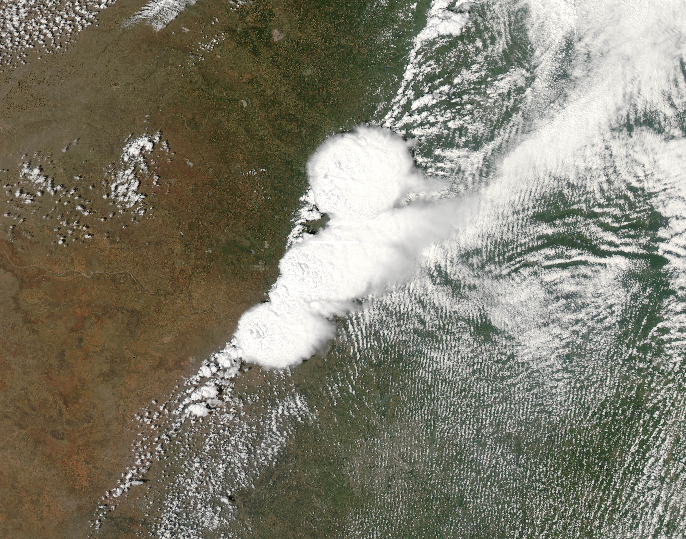
Satellite Image Of Oklahoma Tornado From NASA's MODIS

The Moderate Resolution Imaging Spectroradiometer (MODIS) on NASA’s Aqua satellite acquired this natural-color satellite image of the Oklahoma tornado system at 2:40 p.m. CDT (19:40 Universal Time), just minutes before the devastating twister began.

The red line on the image depicts the tornado’s track.

According to the latest report, 24 have died, including 9 children when the devastating tornado ripped through Moore, Oklahoma Monday afternoon.


Free download large image (1 MB, JPEG, 2800x2200)

Friday, February 08, 2013

LDCM Landsat 8 Feb. 11 Launch Date Gets Go Signal

Ready for the launch of Landsat 8 or LDCM?

Managers today gave the "go" to proceed toward a Feb. 11 launch of NASA's Landsat Data Continuity Mission (LDCM) spacecraft atop a United Launch Alliance Atlas V rocket from Vandenberg Air Force Base in California. During today's Flight Readiness Review, managers decided to follow up with a few open issues leading up to the Launch Readiness Review on Friday.

Also taking place today is the Launch Countdown Coordination Meeting, which will pave the way for tomorrow's Countdown Dress Rehearsal.

At this time, the launch is scheduled for 10:02 a.m. PST (1:02 p.m. EST), beginning a 48-minute launch window. The long-range weather forecast calls for mostly clear skies on launch day.

LDCM is the Landsat Data Continuity Mission, continuing the Landsat program's 40-year record of monitoring Earth's landscapes from space. LDCM will expand and improve on that record with observations that advance a wide range of Earth sciences and contribute to the management of agriculture, water and forest resources. LDCM launches from Vandenburg Air Force Base aboard an Atlas V-401 rocket from United Launch Alliance.

The Landsat Program is a series of Earth-observing satellite missions jointly managed by NASA and the U.S. Geological Survey.

Credit: NASA's Goddard Space Flight Center

Tuesday, October 02, 2012

Venezuelan Remote Sensing Satellite Launched

Venezuela launched its second remote sensing satellite called "Francisco de Miranda."

China has launched a second satellite built for Venezuela's government.

The remote sensing satellite soared into orbit atop a rocket from the northwestern Chinese province of Gansu.

The launch was shown live on Venezuelan TV on Friday night. Venezuelan President Hugo Chavez applauded as he watched alongside aides in Caracas, congratulating those who worked on the project.

Officials have said the satellite cost $140 million and will provide images for tasks such as mapping croplands, counter-drug efforts and monitoring floods.

The launch came more than a week ahead of Venezuela's Oct. 7 presidential election, in which Chavez is seeking another six-year term.

The satellite is named after Venezuelan independence hero Francisco de Miranda.

Venezuela's first satellite was named after independence leader Simon Bolivar. It was launched from China in 2008.

SOURCE

Thursday, September 13, 2012

SPOT 6 First Satellite Image!

Below is the a SPOT 6 satellite image acquired 3 days after the launch on September 9. It is an image from Bora Bora French Polynesia.

Title : SPOT 6 Satellite Image - Bora Bora French Polynesia
Location: Society Islands - Pacific Ocean
Image Type: Optical
Resolution: 1m - 5m
Date: 09/12/2012
Copyright: 2012 Astrium Services

Wednesday, April 11, 2012

Oceanic Surveying Satellite Haiyang-2 Goes Public

The State Oceanic Administration (SOA) on Friday gave the public access to data products of the oceanic surveying satellite Haiyang-2, which monitors maritime environment and extreme weather.

The satellite provides services for oceanic disaster prevention and relief, resources exploitation, environmental protection, oceanic research, as well as safeguarding oceanic rights, according to the SOA.

The administration said it will further expand the scope for the implementation of the data from the satellite, and make use of its potential values as much as possible in a bid to provide first-class services to data users.

The satellite was launched mid-August last year.

Earlier this month, control of satellite was handed over to the SOA by its manufacturer and launcher China Aerospace Science and Technology Corporation.

SOURCE news.xinhuanet.com

Thursday, March 15, 2012

SPACEBEL Gets Vietnam Earth Observation Satellite Deals

It is on March 13th 2012, in the frame of a princely trade mission, that SPACEBEL will sign the contractual pre-agreements with the Vietnam Academy of Science and Technology (VAST) for the supply of an Earth observation mini-satellite to be launched in 2017.

After several years of negotiations, the SPACEBEL consortium was selected in July 2011 on the basis of their technical proposal and thanks to the continuous support of the Belgian Government, both at Federal and regional levels.

With this 100% Belgian satellite named VNREDSat-1b (Vietnam Natural Resources, Environment & Disaster Monitoring satellite) Vietnam will be able to monitor independently its territory and environment. Weighing 130 kg, the small spacecraft will play an important role, amongst others, in the field of natural resources management (agriculture, forests), will ensure a better follow-up of climate changes, detect pollution in the seas, help to minimize the impact of natural disasters, etc.

To realize this project representing a total value of over 60 million €, SPACEBEL relies upon the expertise of a panel of Belgian partners: QinetiQ Space, AMOS, Deltatec, the Space Centre of Liège, and VITO, who will be responsible respectively for the satellite platform, hyperspectral instrument, integration and testing, and data processing.

Prime contractor and architect of the system, SPACEBEL will also develop the on-board software as well as the entire ground segment.

A training programme on satellite technology and remote sensing space applications to be set up in co-operation with the University of Liège completes the SPACEBEL offer.

This first successful commercial sale confirms the skills of SPACEBEL in the field of small satellites. At the same time, it is the consecration of the know-how of the Belgian space sector.

SOURCE: SPACEBEL

Wednesday, December 21, 2011

China to Launch Ziyuan III High Resolution Mapping Satellite

China will launch its first-ever high-resolution geological mapping satellite for civil purposes next January, according to official sources.

The Ziyuan III satellite will be launched aboard a Long March 4B carrier rocket from the Taiyuan Satellite Launch Center in northern China's Shanxi province, according to a conference held on Monday for the directors of surveying, mapping and geoinformation administrations across the nation.

The Ziyuan III's surveying covers the entire area between 84 degrees north latitude and 84 degrees south latitude.

The satellite will be used to conduct geological mapping, carry out surveys on land resources, help with natural disaster-reduction and prevention, and lend assistance to farming, water conservation, urban planning and other sectors.

The Ziyuan III satellite project was inaugurated on March 2008, and also includes gravity satellites, radar satellites and follow-up satellites for the Ziyuan III, so as to obtain geoinformation under all kinds of meteorological conditions.

SOURCE xinhuanet.com

Thursday, December 01, 2011

Free Amazon-1 Satellite Images

Images of the Amazon-1, the first satellite developed entirely in Brazil, to be launched in 2013 and will feature powerful cameras to monitor tropical forests, will be offered free of charge to neighboring countries, official sources said today. The images from the Amazon-1 also will be included in the Brazilian policy of free access to satellite data, said the head of the Division of Sea, Antarctica and Space of the Ministry of Foreign Affairs, Fabio Pitaluga was quoted in a statement the National Institute for Space Research (INPE). This policy, which pioneered the world INPE in 2004, was defended by the diplomat on Wednesday during the opening ceremony of the annual meeting of the Group of Earth Observation (GEO, for its acronym in English) in Istanbul (Turkey).

In his speech, the minister highlighted the various initiatives of INPE to share its satellite images with other countries and transferring technology to the neighbors, said the state agency a statement. "Brazil believes in an open data policy libres.Brasil, which adopted this policy for all Earth observation satellites, launched in 2013 the Amazon-1, a satellite that aims to monitor the forest and agriculture in tropical regions of the world, "said Pitaluga in his speech to the members of the GEO, the intergovernmental organization which aims to set up a global system for distribution of satellite data. "Brazil has developed an open source software to process surveillance images remote and analyze geographic information and spatial data. Such software is already widely used in Latin America and we aim to expand its use to other developing nations of Asia and Africa, "the diplomat added.

In addition to providing data from their satellites, the INPE help in the training of technicians from the countries that benefit from free access to the images. The free offer of images began in 2004 with CBERS data (the set of satellites developed, launched and operated jointly by Brazil and China) and it was extended to all other satellites operated by INPE him, including the Amazon-1. "Brazil bets on technology transfer for the monitoring of tropical forests to other developing nations. We are helping other countries to develop their ability to measure and monitor forest carbon stocks, "according Pitaluga. The Amazonia-1 will increase the accuracy of the software developed by Brazil to monitor deforestation of tropical forests by analyzing satellite images. This is because the Brazilian AWFI optical camera (Advanced Wide Field Imager) which is equipped with the ability to operate on the fringes of the visible and the infrared, and will have a resolution of 40 meters and a capacity to take pictures of areas up to 780 kilometers.

The satellite will also feature a camera RALCam-3 developed in England and able to produce images with resolution of 12 meters in areas of 110 km. Pitaluga used his speech to thank the GEO's decision to organize its next annual meeting in the Brazilian city Foz do Iguassu late next year.

SOURCE LaEstrella

Saturday, August 20, 2011

Chinese Ocean Observation Satellite Haiyang 2A Launched

A Chinese ocean observation satellite launched Monday on a Long March rocket from the Taiyuan space center in northeastern China, according to state-run media.

The Haiyang 2A satellite lifted off at 2257 GMT (6:57 p.m. EDT) from the Taiyuan launching base in Shanxi province, the state-owned Xinhua news agency reported. Launch occurred at 6:57 a.m. local time in Beijing.

The remote sensing payload flew into orbit on top of a Long March 4B rocket, which placed the satellite in a 565-mile-high orbit with an inclination of 99 degrees, according to independent tracking data.

Xinhua declared the launch a success in its reporting.

China says Haiyang 2A will aid the supervision and survey of the maritime environment, helping prevent potential disasters at sea and contributing to marine weather forecasts.

The satellite features upgrades over two earlier ocean observing craft launched by China in 2002 and 2007. Haiyang 2A will study dynamic ocean environments such as sea surface winds, wave height and water temperatures.

Its instruments include a microwave sensor, a radiometer and an altimeter.

Earlier Haiyang 1 satellites monitored ocean pollution and shallow waters to help in the operation of harbors and ports. A third generation of satellites is planned to combine the Haiyang 1 and Haiyang 2 missions.

Monday's Long March flight was the eighth space launch of the year for China's space program. The nation plans a feverish pace of space missions for the rest of 2011, including the launch of a man-rated space laboratory, the program's first orbital docking attempt, and more rocket flights with communications, military and scientific payloads.

Tuesday, June 21, 2011

Rasad Satellite Beams First Iran Images

Iran receives first images from home-made Rasad satellite. Read the report:
Iran announced on Sunday that it has received the first images and data sent by the country's second domestically-made satellite, 'Rasad' (Observation) which was sent into orbit Wednesday evening.

"We have received the first satellite images and telemetric data from Rasad this morning," President of Malek Ashtar University affiliated to Iran's defense ministry Reza Mozaffarinia said on Sunday, Fars news agency reported.

Mozaffarinia also expressed pleasure that the data received from the satellite indicate that all systems of Rasad are working even better than what has been predicted before.

Rasad which weighs 15.3 kilograms and was designed to be launched into the 260 kilometer orbit of the earth rotates around the earth 15 times in 24 hours.

Saturday, May 28, 2011

Venezuela Second Remote Sensing Satellite to Launch Soon

Venezuela and China today signed a manufacturing contract for the second satellite, which will be launched in October 2012, the Venezuela News Agency reported, via People's Daily Online.

"This remote sensing satellite will be for monitoring the development and impact of natural phenomena, such as earthquakes, floods and heavy rains," said Menendez, the minister for Science, Technology and Intermediate Industries.

The construction of a second satellite with a designed service life of five to six year has begun and it will cost Venezuela 1.4 billion dollars.

In October 2008, China handed over the first Chinese-built telecommunication satellite to Venezuela.

Saturday, April 16, 2011

Vietnam Remote Sensing Satellite VNREDSat-1 Coming Soon

Vietnam will launch its first remote sensing satellite in 2014, according to the Space Technology Institute of the Vietnam Academy of Science and Technology, via VOVNews.

The Head of the Space Technology Institute, Associate Professor Doan Minh Chung said that the satellite, called VNREDSat-1, will be designed and assembled using French technology in 2013.

The 130kg satellite will be capable of capturing earth images from almost 700km into space, to monitor and study the effects of climate change, monitor natural disasters and manage natural resources and the environment.

The VNREDSat-1 project has a total investment of EUR55.8 million sourced from the French Government’s official development assistance. The project will include the lease of a satellite launching pad and advisors to the project.

The launch of the satellite and an image receiving and processing station will save Vietnam expenditure on purchasing satellite pictures as well as information and data on storms, floods, forest fires and oil spills, he said.

The project will be carried out by the academy as part of its strategy on space technology application and research until 2020.

Earlier, with the cooperation of US aerospace manufacturer Lockheed Martin, Vietnam successfully launched the VINASAT 1 satellite to provide telecom services.

Monday, July 19, 2010

Russian Cosmos SX Remote Sensing Satellite Tested

Russian engineers from Krasnoyarsk have successfully tested a model of a new remote sensing satellite “Cosmos SX”.

Tests confirmed strength characteristics of the satellite. Engineers plant to continue introduction of newest technological solutions to the satellite – making solar battery panels weigh less, for instance, which makes technical characteristics of the vehicle much better.

“Cosmos SX” remote sensing satellites will provide high-accuracy data on farming lands state, as well as predict and estimate cropping capacity. Moreover, new space vehicles will allows predicting draughts, floods and other natural disasters.

Tuesday, June 22, 2010

TanDEM-X German Radar Satellite Launced

TanDEM-X Launched Successfully: TerraSAR-X twin brought into orbit from Baikonur // Satellite formation will collect data for global DEM.

The German radar satellite TanDEM-X was successfully launched from Baikonur, Kazachstan, at 04.14 hrs CET on Monday, June 21, 2010. A first contact with a ground station in Troll was established at 04.45 hrs.

TanDEM-X joins its "twin" TerraSAR-X, which has been in operation since mid 2007, in its 514 km orbit. Together, the two satellites will spend three years collecting stereo radar data for a global digital elevation model of the Earth's entire landmass. This DEM will feature a relative accuracy of better than 2 meters (10 meter absolute) for a 12 meter grid.

"This successful launch is an important step forward for our company," stated Dr. Vark Helfritz, Managing Director of Infoterra GmbH, following the successful launch: "Infoterra will be conducting the commercial marketing of this unique global DEM, which will of course be an attractive enhancement of our companies' portfolio."

TanDEM-X is being implemented in a Public-Private Partnership (PPP) between the German Aerospace Centre (DLR) and Astrium GmbH with, funds from the German Ministry of Industry and Technology (Bundesministerium für Wirtschaft und Technologie).

Infoterra GmbH will be responsible for the commercial marketing of the elevation model, which will involve customising the DEM to the needs of commercial users: Infoterra will process the raw data supplied by the satellite system in accordance with specific customer requirements. This involves removing any remaining spikes (peaks or outliers caused by noise) and offsets (can occur due to radar shadow particularly in mountainous terrain) in the data, and editing the representation of expanses of water (ensuring a uniform water level and the right gradient of river courses).

Wednesday, October 21, 2009

WorldView-2 high-resolution, 8-band multispectral satellite images, released

DigitalGlobe, a leading global provider of commercial high-resolution world-imagery products and services for defense and intelligence, civil government, and commercial customers, today released the first images from WorldView-2, the company’s most recent high-resolution, remote-sensing satellite. Initial images, issued after just 11 days on orbit, captured Love Field Airport near Dallas and the AT&T Center in San Antonio, Texas. More refinements to early-stage images can be expected as the ongoing check-out and calibration continues.

WorldView-2 was successfully launched on October 8, 2009, and is currently completing its routine calibration and check-out period. DigitalGlobe expects the satellite to be operational and delivering commercially available imagery products and services approximately 90 days from the launch date.

The launch of WorldView-2 marked another first for DigitalGlobe and the industry as the first high-resolution, eight-band, multispectral commercial satellite. WorldView-2 is expected to improve the speed and rate of imagery delivery to the government and commercial markets with large-scale collection capacity and daily revisit rates. WorldView-2 joined DigitalGlobe’s existing sub-meter satellites on orbit, QuickBird and WorldView-1, to enable an annual imaging capacity equivalent to three times the earth’s land mass.

WorldView-2 collects multispectral imagery at 1.8 meter resolution and panchromatic imagery at 0.46 meters.[i] The additional multispectral band capability supports improved levels of feature identification and extraction and more accurately reflects the world’s natural color.

DigitalGlobe will preview first imagery from WorldView-2 at booth #591 at the GeoInt 2009 Symposium this week in San Antonio, Texas.

More WorldView-2 first images here.