Showing posts with label MODIS. Show all posts

Tuesday, June 28, 2011

Download MODIS Images of Flooding Along Missouri River

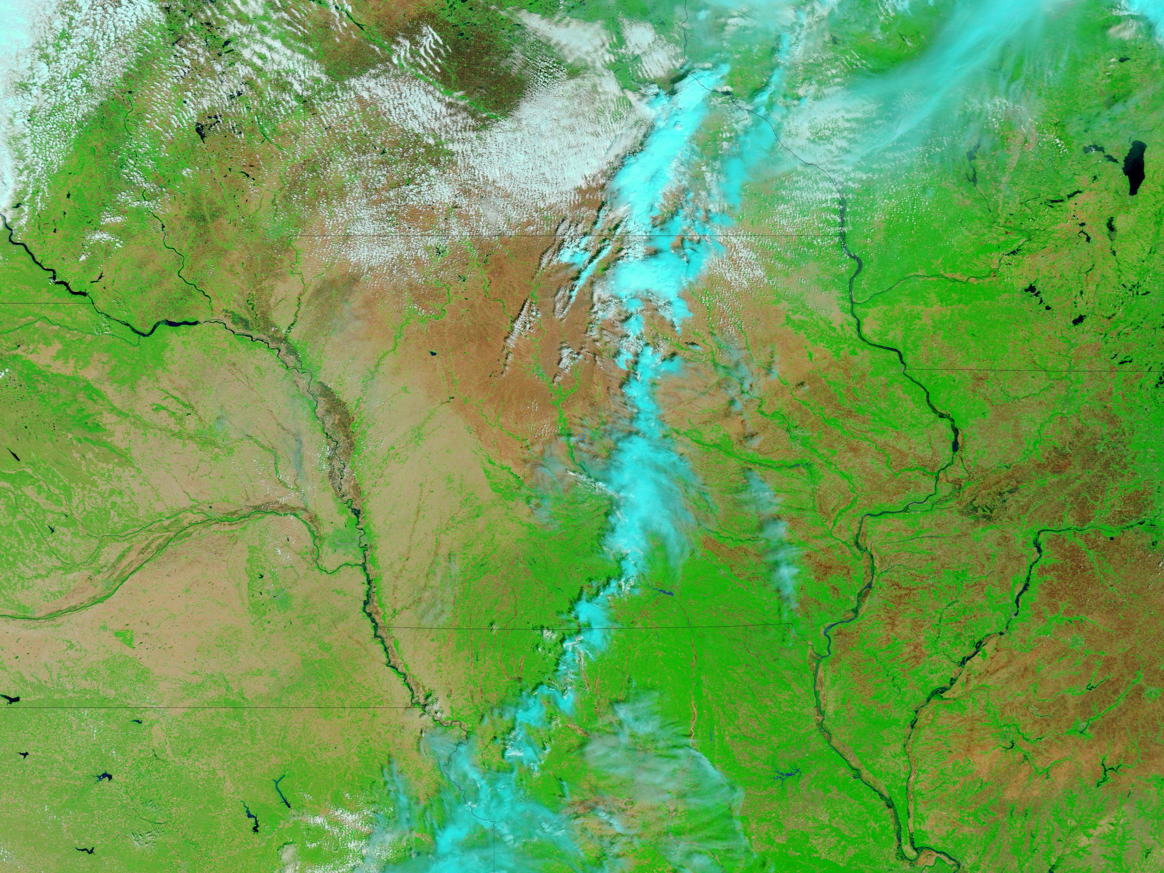
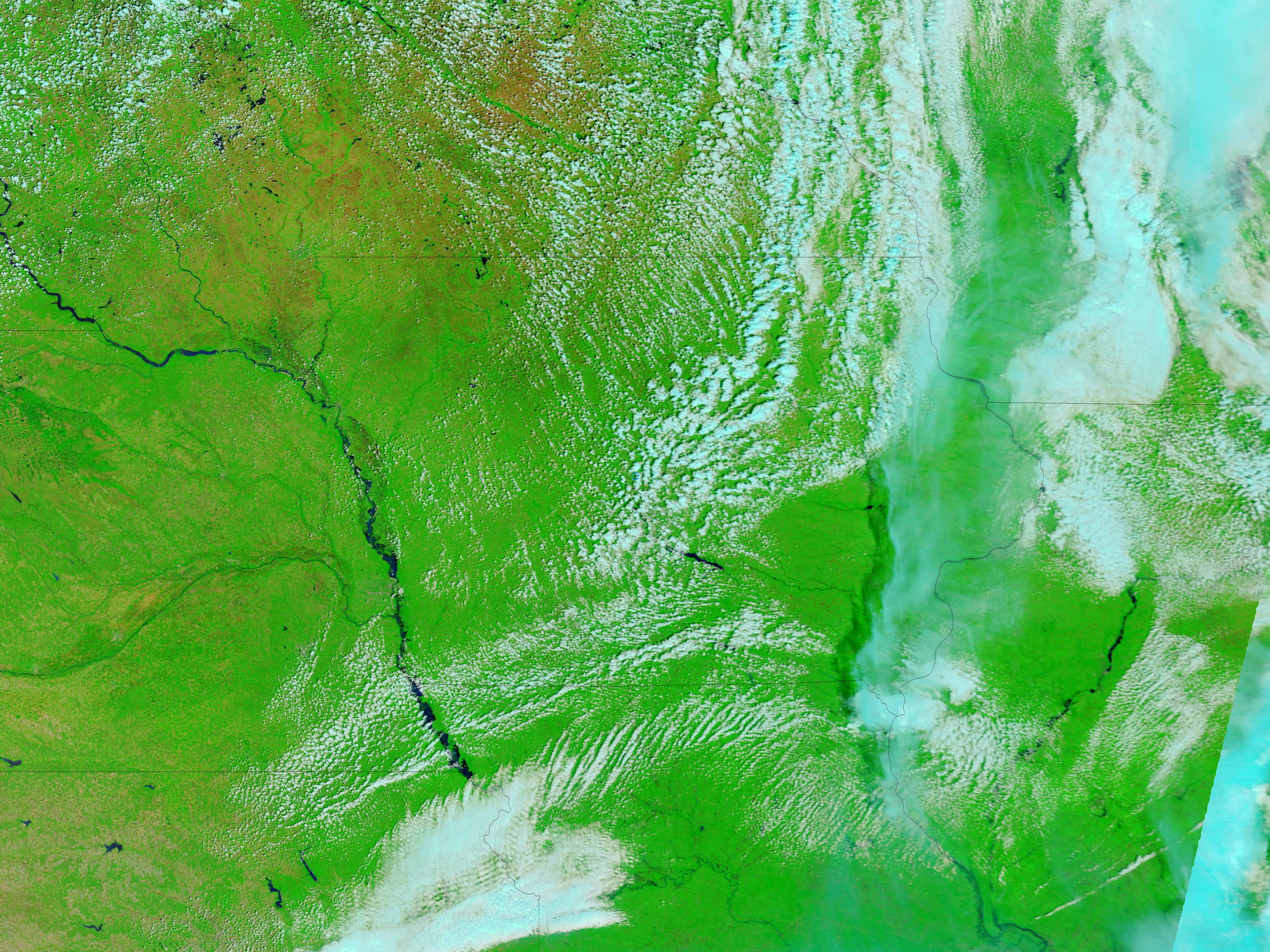
The MODIS Rapid Response Team released the recent MODIS images of the flooding along the Missouri River. The satellite images show the advance of flood waters on the Missouri River between May 30, 2011 and June 27, 2011.

No significant flooding appears along this stretch of the Missouri on May 30. On June 1, flooding had begun to occur near the North Dakota town of Williston, upstream from Lake Sakakawea.

Download for free the May 30, 2011 MODIS image (large image, 4 MB, JPEG).

Download for free the June 27, 2011 MODIS image (large image, 4 MB, JPEG).

Thursday, June 16, 2011

What Happens When Reading MODIS Level 1 Data

This is what happens when reading MODIS Level 1 data. I took this solution from the ENVI help and inforest.gr forum.

* MODIS: Reads MODISModerate Resolution Imaging Spectroradiometer; a NASA EOS sensor aboard the Aqua and Terra satellites. Level 1B, 2, 3, or 4 files (MODIS products MOD02-MOD44 and MYD02-MYD44). The gainIn ENVI, a value that is multiplied by the pixel value to scale it into physically meaningful units of radiance: radiance = DN * gain + offset and offsetIn the context of remote sensing: A correction value added
to or subtracted from every pixel in an image, typically by using image arithmetic (Band Math in ENVI). A variable added to the gain in a regression equation for sensor calibration. The number of bytes of embedded header information present in the file (ENVI skips these bytes when reading the file).

Values are also extracted from the HDF metadata. These values are automatically applied when ENVI converts the 16-bit data in the input file to calibrated floating-point data. The resulting emissive and reflectance data are unitless. The units of the radiance data are W/m2/m/sr. You can disable applying gains and offsets information with the Auto-Correct ASTER/MODIS preference.

Note: For EOS MODIS Level 1B files, values greater than 32767 (which indicate invalid data) are replaced by -1 when applying the gains and offsets. The data ignore value in the ENVI header is also set to -1.

To open MODIS products M*D08*, M*D27HV, M*D27W, M*D43B1, M*D43B1C, M*D43B2, M*D43B2C, M*D43B3, M*D43B3C, M*D43C2, M*DATML2, use File > Open External File > Generic Formats > HDF.

Friday, April 16, 2010

Iceland Volcano Satellite Image - More MODIS Images

More Iceland Volcano MODIS satellite images released by NASA. The MODIS Rapid Response System was developed to provide daily satellite images of the Earth's landmasses in near real time.

For more information and a real-time MODIS image gallery, visit MODIS link.

Eruption of Eyjafjallajökull Volcano, Iceland


Credit: NASA/MODIS Rapid Response Team

Wednesday, October 28, 2009

MODIS Satellite Data to Enhance XMWX Product to Track Fish

WorldWinds, Inc. and the NASA Short–term Prediction Research and Transition Center (SPoRT) at the Marshall Space Flight Center have enhanced a product to track favorable conditions of certain pelagic fish species. The daily Chlorophyll–a composite product uses data from NASA’s MODIS satellite and has been applied in the XMWX commercial weather product which provides live, site-specific atmospheric and oceanographic information to motorists, boaters, outdoorsmen, commercial mariners, and emergency personnel allowing them to make more informed decisions while saving time and fuel.

Mariners are among those most in need of reliably available, quality meteorological and oceanographic information. The difference between reliable, quality data and otherwise can have a huge impact on completing a job, having a successful research cruise, the efficient use of fuel, safety, or enjoyable recreation. The equipment needed to receive and display the data, a small antenna, with embedded receiver, and a display device, can be installed in any type of home or vehicle. This weather data is available anywhere in the continental United States and up to 600 miles offshore in coastal US waters. An accompanying GPS option also makes it possible for users to plot their own position on the interface map, showing their movements in relation to storms and other features.

To provide mariners with all of the needed aspects of meteorological and oceanographic data, WorldWinds and partners WxWorx ( www.wxworx.com) and XM Satellite Weather, developed a suite of data products, dubbed XMWX, that includes: current in–situ measurements; sea surface temperature; significant wave height, period, and direction; current and forecasted wind, sea level pressure, and visibility; cloud cover mosaic; marine zone forecasts, additional in–house proprietary data, including FishBytesTM, and other pertinent information.

Funding and support for this project is from the NASA SPoRT group at Marshall Space Flight Center. WorldWinds has made this data available to the public. Data is posted to the public web site within one hour of the daytime MODIS/Aqua collection and can be accessed at: http://www.worldwindsinc.com/Chlorophyll.htm.

WorldWinds presented the results of the project at OCEANS ’09 Conference. The project is also included in the upcoming October issue of NASA’s Spinoff magazine.

Friday, February 06, 2009

ORNL DAAC MODIS Tool Update

The ORNL DAAC discontinued the distribution of Collection 4 MODIS Land Product Subsets on January 31, 2009, as part of the MODIS Land Team's switch from Collection 4 to Collection 5. The Collection 5 products and subsets, created using improved algorithms, have been available since September 2006.

The ORNL DAAC will continue to offer Collection 5 MODIS Land Product Subsets in a variety of ways including:

1. Subsets for over 1,000 fixed sites world wide in ASCII and GeoTIFF formats: http://daac.ornl.gov/modisfixedsite

2. Subsets for any user selected site world wide in ASCII and GeoTIFF formats: http://daac.ornl.gov/modisglobal

3. Programmatically obtain ASCII subsets using SOAP based Web Service [Beta]: http://daac.ornl.gov/modiswebservice

The ORNL DAAC is also pleased to announce the following updates to our MODIS Global Tool:

1. Availability of 500-m Collection 5 MODIS land cover product (MCD12Q1)

2. Stackable time series visualization for inter-annual comparison

For more information about ORNL DAAC MODIS products see: http://daac.ornl.gov/MODIS/modis.html .

The ORNL DAAC is a NASA-funded center archiving and distributing terrestrial ecology and biogeochemical dynamics data.

Saturday, June 07, 2008

MODIS and ASTER Data Products

Download MODIS Data Products from the Land Processes (LP) Distributed Active Archive Center (DAAC). The LP DAAC was established as part of NASA's Earth Observing System (EOS) Data and Information System (EOSDIS) initiative to process, archive, and distribute land-related data collected by EOS sensors, thereby promoting the interdisciplinary study and understanding of the integrated Earth system.

Landsat 7 was launched successfully on April 15, 1999, and the EOS Terra satellite (formerly EOS AM-1) was launched on December 18, 1999. Terra carries two sensing systems for which the LP DAAC has data processing and/or distribution responsibilities. These are the Advanced Spaceborne Thermal Emission and Reflection Radiometer (ASTER) and the Moderate Resolution Imaging Spectroradiometer (MODIS). In addition, the MODIS sensor on the Aqua spacecraft acquires data delivered to the LP DAAC for storage and distribution. Numerous ASTER and MODIS data products are available from LP DAAC.

Download MODIS and ASTER Data Products.